Virginia--Blue Ridge Parkway North
Date: 2004-12-12
 The best time to take this drive is mid-week as summer and fall weekends
mean heavy traffic. The Blue Ridge Parkway travels along the crest of
the Appalachian Mountains from Virginia's Shenandoah National Park to
the Great Smoky Mountains National Park in Tennessee and North Carolina,
offering breathtaking views along the way.
The best time to take this drive is mid-week as summer and fall weekends
mean heavy traffic. The Blue Ridge Parkway travels along the crest of
the Appalachian Mountains from Virginia's Shenandoah National Park to
the Great Smoky Mountains National Park in Tennessee and North Carolina,
offering breathtaking views along the way.
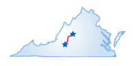
This drive covers the northern portion of the Parkway from Rockfish Gap to Roanoke. Begin in Rockfish Gap at the intersection of Exit 99 on I-64 and U.S. 250. Heading south on the parkway, the road will begin to climb steeply, offering views of the Shenandoah Valley on the right. The Appalachian Trail parallels the parkway with access points along the road. In about five miles you'll come to the Humpback Rocks area--its several trail heads include one with reconstructed pioneer log buildings. Five miles beyond, you may want to stop at Ravens Roost for more views of the Shenandoah Valley. Take a short side trip to Sherando Lake--about four miles from the parkway on Virginia Highway 814 in the George Washington National Forest--for a lakeside picnic.
Farther on, pull off at one of the many scenic overlooks to see the Religious Mountains--the Cardinal, Friar, and Priest. Just beyond mile 53 on the Parkway, you'll find the 630-foot-long Bluff Mountain Tunnel, the only tunnel on the Virginia portion of the parkway. A short distance from the tunnel is the Otter Creek Recreation Area, a popular spot with hikers and fishers. You can take a tour led by a naturalist, or eat in the restaurant and shop in the gift shop.
You'll know you have entered the George Washington National Forest when you cross the James River, an important transportation link prior to the advent of the railroad. There are many overlooks offering great vistas of this winding waterway. Soon, the drive reaches its highest point (3,950 feet) at the Apple Orchard turnout. At mile 83.1, park your car and follow the trail markers leading to the Falling Water Cascades Trail. At mile 99.6, you'll see views of the Roanoke Valley and the Great Valley, a continuation of the Shenandoah Valley.
Fifteen miles down the road, take the Roanoke River Valley to Virginia's Explore Park, a frontier museum with a blacksmith shop, a 19th Century school, and a farm. Roanoke itself has some great restaurants and shops as well as the Science Museum of Western Virginia with its many hands-on exhibits.
Starting Point:
Rockfish Gap, VA
Distance of Drive:
115 miles
Must Eat:
Roanoker
2522 Colonial Avenue, Roanoke, VA 24015
Phone:540-344-7746
Call ahead to confirm hours of operation.
Best Time of Year for Drive:
Summer to fall (mid-week)
Points of Interest on Drive:
Shenandoah Valley
Virginia's Explore Park
Religious Mountains
Comments to this article have been disabled.