Try hwy 27
Mississippi--Natchez Trace Parkway
Date: Tuesday, 04. September 2007
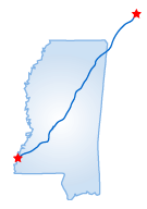 The Natchez Trace Parkway is a 429-mile drive from Franklin, Tennessee
to Natchez, Mississippi. The trip takes two to two-and-a-half days. After
visiting the Carnton Plantation in Franklin, head west out of town to
Rte. 96. The Trace progresses through woods and open fields on the way
to the Gordon House, one of the few remaining structures on the old Trace.
Just past Gordon House lies Jackson Falls and a tobacco farm featuring
exhibits on tobacco growing. A two-mile drive along the original Old Trace
begins here.
The Natchez Trace Parkway is a 429-mile drive from Franklin, Tennessee
to Natchez, Mississippi. The trip takes two to two-and-a-half days. After
visiting the Carnton Plantation in Franklin, head west out of town to
Rte. 96. The Trace progresses through woods and open fields on the way
to the Gordon House, one of the few remaining structures on the old Trace.
Just past Gordon House lies Jackson Falls and a tobacco farm featuring
exhibits on tobacco growing. A two-mile drive along the original Old Trace
begins here.
On the other side of open farmland lies the Sweetwater Branch nature trail. Another 20 miles of woods brings you to the Alabama border. Cross the Tennessee River at Colbert Ferry and follow the quarter-mile Freedom Hills Overlook trail. Continue south on Rte. 96 into Mississippi. When crossing the Jamie L. Whitten Bridge over the Tennessee-Tombigbee Waterway, keep in mind that the idea to build the bridge came in the mid-1700s and it was finally completed in 1985. The 90-acre Pharr Mounds is located a few miles south of the Tenn-Tom Waterway. There are eight dome-shaped burial mounds built around 2,000 years ago. Stop by the park's headquarters at the Natchez Trace Parkway Visitor Center. Here you can learn more about the Trace.
From here, enter the Tombigbee National Forest and stop under the fragrant pines at Witch Dance. Continuing south you will pass the remains of Bynum Mounds. Visit the Kosciusko Visitor Center in the town of Kosciusko, the birthplace of Oprah Winfrey. Outside of town, view the Pearl River and Cypress Swamp. Following the shore of Ross Barnett Reservoir leads you to the Mississippi Crafts Center at Ridgeland. Here you can purchase Choctaw baskets, pottery, quilts, and other crafts. Pass through Jackson, the capitol of Mississippi, to the Sunken Trace, a trail along an eroded portion of the old Trace. Thirty miles to the south is Mount Locust, the only inn still on the Trace and one of the oldest structures in the state. The second largest Indian burial ground, Emerald Mound, is located five miles from Mount Locust.
Starting Point:
Franklin, TN
Distance of Drive:
458 miles
Must Eat:
Biscuits and Blues
315 Main St., Natchez, MS 39129
Phone: 601-446-9922
Call ahead to confirm hours of operation.
Good Stop For: Smoked Ribs
Best Time of Year for Drive:
Spring to Fall
Points of Interest on Drive:
Tombigbee National Forest
Pharr Mounds
Ross Barnett Reservoir
Further comments to this article have been disabled.
All Comments (2)
Showing 1 - 2 comments
![]() Fale,
Fale,
![]() David,
David,
I want to know where do I get off the Parkway closest to Utica,Mississippi