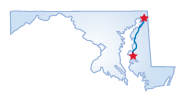
Maryland--Chesapeake City to Bay Bridge
Date: 2004-11-18
 A drive along the upper eastern shore of Maryland will take you through
farm country, historic towns, and nature preserves; you will never once
be far from the water. Begin your trip on Rte. 213 in Chesapeake City
at the western end of the Chesapeake and Delaware Canal. This is one drive,
as you head south, where there are many opportunities to walk along the
way as you visit some interesting tourist sites. In fact, a way to begin
the trip is with a visit to the Canal Museum, where you can learn about
how the area grew in the 1830s as a result of canal-related industries.
A drive along the upper eastern shore of Maryland will take you through
farm country, historic towns, and nature preserves; you will never once
be far from the water. Begin your trip on Rte. 213 in Chesapeake City
at the western end of the Chesapeake and Delaware Canal. This is one drive,
as you head south, where there are many opportunities to walk along the
way as you visit some interesting tourist sites. In fact, a way to begin
the trip is with a visit to the Canal Museum, where you can learn about
how the area grew in the 1830s as a result of canal-related industries.
A stroll through Chesapeake City's historic district will further steep you in history. The 19th Century will come alive in these well-preserved houses and shops. Pass through Fredericktown and cross the Sassafras River to Kent County and the historic town of Georgetown. You'll see the two brick houses that were saved from the British during the War of 1812 when Kitty Knight refused to flee, declaring, "If you burn this house, you'll burn me with it." The highway continues through rolling farmland to Chestertown. Start at the Kent County Visitor Center and take a self-guided walking tour to see the Georgian homes, the courthouse, and the Emmanuel Episcopal Church with its Tiffany window. There are also plenty of shops, galleries, and antique stores.
For natural beauty, take Chestertown's High Street, Rte. 20, to Rock Hall, a bayside community shaped by maritime trade. With 15 marinas, this town is the pleasure boating capital of the upper shore. If you're not inclined to pursue a water adventure, enjoy the fruits of the sea at one of the many seafood restaurants. You may also choose to visit the Rock Hall Museum and an old fashioned drugstore with an authentic soda fountain, both on Main Street. Head south out of town on Main Street, which becomes Rte. 445 to the Eastern Neck Wildlife Refuge, an island ecosystem with extensive hiking trails and plenty of wildlife, including Bald Eagles, more than 240 species of birds and waterfowl, and the endangered Delmarva Fox Squirrel.
Head back to Rte. 213, you will drive through the picturesque Queen Anne's County to Centreville, the county seat. South of Centreville, get on to Rte. 18 and head toward Kent Narrows, a waterfront village bustling with maritime industry and recreation. The town was settled in 1631 when a Virginian set up a trading post here three years before settlers established the colony of Maryland. Next, cross U.S. 50 to Stevensville, an 1850s village that is largely unchanged from its early days with 100 preserved buildings in its historic district. Continuing west on U.S. 50, you will cross the Bay Bridge, the gateway connecting the eastern and western shores.
Starting Point:
Chesapeake City, MD
Distance of Drive:
68 miles
Must Eat:
Fisherman's Inn
3116 Main St. Grasonville, MD 31638
(on Rte. 50 just before Bay Bridge)
Phone:410-827-8807
Call ahead to confirm hours of operation.
Good Stop For:Seafood
Best Time of Year for Drive:
Spring to fall
Points of Interest on Drive:
Eastern Neck Wildlife Refuge
Sandstone Falls
Rock Hall Museum
Comments to this article have been disabled.