Louisiana--The Creole Nature Trail
Date: 2004-11-17
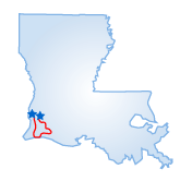 This 105-mile, 2-1/2 hour route winds through marshes, prairies, wildlife
refuges, and Gulf shoreline in southwestern Louisiana and is a favorite
of birding and shelling enthusiasts. The drive is best accomplished fall
through spring, and insect repellant is strongly recommended. The drive
sets off from Sulphur, just west of Lake Charles on I-10. Its name is
derived from the huge mineral deposits found in a nearby salt dome. Heading
south on Rte. 27, it crosses the Intercoastal Waterway and passes Calcasieu
Lake. Beyond the bridge, the landscape changes dramatically to a brackish
tidal marsh, followed by a shipping channel and oil fields. It then continues
on through Hackberry where many shrimp boats traverse Calcasieu Lake.
This 105-mile, 2-1/2 hour route winds through marshes, prairies, wildlife
refuges, and Gulf shoreline in southwestern Louisiana and is a favorite
of birding and shelling enthusiasts. The drive is best accomplished fall
through spring, and insect repellant is strongly recommended. The drive
sets off from Sulphur, just west of Lake Charles on I-10. Its name is
derived from the huge mineral deposits found in a nearby salt dome. Heading
south on Rte. 27, it crosses the Intercoastal Waterway and passes Calcasieu
Lake. Beyond the bridge, the landscape changes dramatically to a brackish
tidal marsh, followed by a shipping channel and oil fields. It then continues
on through Hackberry where many shrimp boats traverse Calcasieu Lake.
Before long, you'll enter the 125,000-acre Sabine National Wildlife Refuge, the Gulf Coast's largest waterfowl refuge with more than 250 species. Four miles beyond, you just might see alligators, egrets, Roseate Spoonbills, and other seasonal fowl on the 1-1/2 mile Marsh Trail. The gulf town of Holly Beach is up next, offering exceptional shelling from October through February. Turning left onto Rte. 27/82 you'll head east. Take a free ferry ride across the shipping channel to Cameron. Vistas of coastal vegetation mark the ride into Creole, where you'll turn north on Rte. 27.
Again crossing the Intercoastal Waterway, the drive enters the Cameron Prairie National Wildlife Refuge, with its grasslands and farmlands that attract ducks, doves, and rare black rails. Next, turn west onto Rte. 384 heading through the rice fields, turn north onto Rte. 385 and continue to the drive's end in the port of Lake Charles, where the town's historic Charpentier District features about 20 blocks of vintage Victorian architecture.
Starting Point:
Sulphur, LA
Distance of Drive:
105 miles
Must Eat:
Pujo Street Cafe
508 Pujo Street, Lake Charles, LA 70601
Phone:337-439-2054
Call ahead to confirm hours of operation.
Good Stop For:Seafood / Steaks
Best Time of Year for Drive:
Fall to spring
Points of Interest on Drive:
Sabine National Wildlife Refuge
Cameron Prairie National Wildlife Refuge
Comments to this article have been disabled.